Published 1 July 2022
Basseterre
Buckie Got It St. Kitts and Nevis News Source
SmallCraftADVISORY1.7.2022
Forecast valid until 2nd July,2022 at 8am.
Small craft advisory valid until Saturday afternoon.
Weather Bulletin
Issued at: 7am Friday, 1st July 2022
Present Weather: Cloudy with slight dust haze
Winds: A moderate breeze of 14mph from the northeast
Temperature: 27°C / 81°F Humidity: 77%
Sea Level Pressure: 1015.3mbs or 29.98″
Sunset: Today 6:49pm Sunrise: Tom 5:41am
Weather Forecast Valid until 8 am Tomorrow
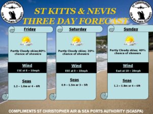
Winds: East-northeast at 10 to 18 mph today but increasing to 15 to 25 mph
tonight and tomorrow during the passage of the wave. Gusts to 35 mph are possible
in some showers.
Seas: 1.6 to 2.4 meters or 6 to 8 feet. A small craft advisory remains in effect.
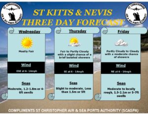
Weather Forecast for St. Kitts & Nevis: Relatively stable conditions will continue over the Leewards today; however, by tonight, skies will become increasingly cloudy ahead of an approaching tropical wave. By early tomorrow, the northern portion of the wave will begin interacting with an upper level low and this could result in some showers becoming locally heavy at times. Rainfall accumulation between 5 to 12.5 mm .20 to .50 inch is possible up to 8 am tomorrow with higher amounts possible thereafter. A flash-flood watch may become necessary for portions of the Leewards later today in anticipation of heavier rainfall during the daytime hours tomorrow.
Weather today: Partly sunny with a 40 percent or moderate chance of a brief passing afternoon shower
Weather tonight: Becoming increasingly cloudy with occasional overnight and early morning showers
Eastern Caribbean Forecast: An active tropical wave will be moving over the Windwards and islands further south today. Skies over these islands will be cloudy to sometimes overcast with occasional showers and scattered thunderstorms, some of which could be locally heavy at times. As the wave move westward, the northern portion will interact with an upper level low over the Leewards to generate similar
weather conditions over these islands beginning tonight with the more intense rainfall expected Saturday morning which could result in flash-flooding in low-lying and flood prone areas. Meanwhile, shallow pockets of moisture will result in brief periods of cloudiness and passing showers over British Virgin Island and Puerto Rico.