Published 23 August 2022
Basseterre
Buckie Got It St. Kitts and Nevis News Source

Tropical Weather Outlook
NWS National Hurricane Center Miami FL
200 PM EDT Tue Aug 23 2022

For the North Atlantic...Caribbean Sea and the Gulf of Mexico:

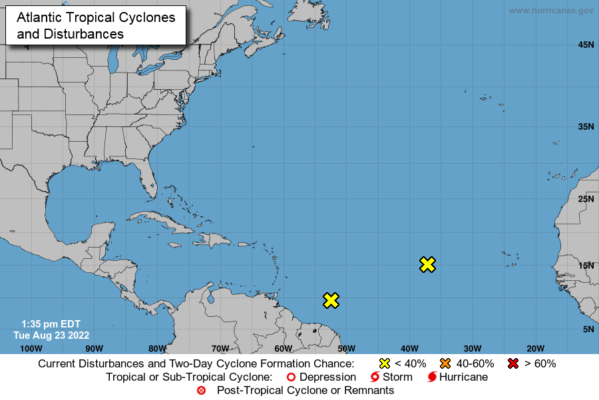
1. Central Tropical Atlantic:
Shower activity remains minimal in association with a tropical
wave located several hundred miles west of the Cabo Verde Islands.
Further development of this system is not expected during the next
several days while the system moves westward to west-northwestward
at 10 to 15 mph across the tropical Atlantic.
* Formation chance through 48 hours...low...near 0 percent.
* Formation chance through 5 days...low...near 0 percent.

2. East of The Windward Islands:
A large area of disturbed weather has formed centered several
hundred miles east-southeast of the Windward Islands.  While this
system is currently disorganized, environmental conditions could
become more conducive for development in a few days when the system
approaches the Windward Islands or southeastern Caribbean Sea.
* Formation chance through 48 hours...low...near 0 percent.
* Formation chance through 5 days...low...20 percent.

3. Eastern Tropical Atlantic:
A tropical wave is forecast to move off the west coast of Africa in
a couple of days.  Environmental conditions could support some slow
development of this system late this week or over the weekend
while it moves westward at 10 to 15 mph.
* Formation chance through 48 hours...low...near 0 percent.
* Formation chance through 5 days...low...20 percent.

Forecaster Blake/Hogsett
National Hurricane Center Monitoring System With Potential For Slow Development in Coming Days

The National Hurricane Center is monitoring a slow-developing tropical wave in the Eastern Atlantic Ocean, which N.H.C. says could see slow development in the coming days as conditions encouraging further development appear somewhat conducive.
“A tropical wave located a few hundred miles west of the Cabo Verde Islands continues to produce disorganized showers and thunderstorms,” N.H.C. said. “Environmental conditions could support some slow development of this system while it moves westward to west-northwestward at around 10 to 15 mph across the tropical Atlantic during the next several days.”
Development chance in the next 48 hours is low at near zero percent, while chances grow to 20 percent in the five-day window, according to N.H.C.
Though highly reputed organizations such as the National Oceanic and Atmospheric Administration and the Colorado State University Tropical Weather and Climate Research have predicted an above-average hurricane season this year, it has been so far quiet in the tropical Atlantic. According to NOAA, the peak of the Atlantic hurricane season is September 10, with most activity occurring between mid-August and mid-October.


