Published 13 August 2024
Buckie Got It
St. Kitts and Nevis News Source
TROPICAL STORM ERNESTO CONTINUES TO STRENGTHEN AND APPROACH ST. KITTS AND NEVIS; RESIDENTS ADVISED TO REMAIN ALERT
BASSETERRE, St. Kitts, August 13, 2024 (SKNIS): The National Emergency Management Agency (NEMA) issued an important update as of 11:00 AM regarding Tropical Storm Ernesto, which continues to approach the Federation of St. Kitts and Nevis.
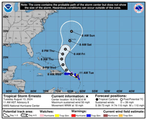
The storm has strengthened with maximum sustained winds now reaching 50 mph, and it continues to pose a threat to the islands. A flash flood warning remains in effect for St. Kitts and Nevis due to the expected heavy rainfall. Additionally, the tropical storm warning and small craft warning continue to be in force for the area.
Current radar data indicates that the Federation is already experiencing moderate to heavy showers, with near storm force winds. Residents should prepare for continued deteriorating weather conditions, including cloudy skies with showers and thunderstorms throughout the day and into the night. There is also a moderate chance of thunderstorms continuing into the evening.
As Tropical Storm Ernesto strengthens and moves closer to the Federation, NEMA strongly advises all residents to take the necessary precautions, secure their property, and remain vigilant. Please continue to monitor official channels for the latest updates, including the NEMA, SKNIS, and ZIZ Facebook pages, as well as other local news platforms.
As of 11:00 AM, the center of Tropical Storm Ernesto is located at 16.9°N, 62.6°W, or approximately 28 miles due south of St. Kitts and Nevis. The storm is moving west-northwest at 18 mph, with a minimum central pressure of 1003 mb.
NEMA will continue to provide timely updates as the situation evolves. Please stay safe and follow all emergency instructions.