Published 18 August 2017
Buckie Got It, St. Kitts and Nevis News Source
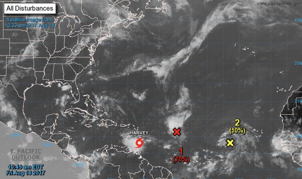
HARVEY MOVING THROUGH THE WINDWARD ISLANDS…
SUMMARY OF 1100 AM AST…1500 UTC…INFORMATION
———————————————–
LOCATION…13.1N 61.3W
ABOUT 15 MI…25 KM SSW OF ST. VINCENT
ABOUT 50 MI…85 KM SSW OF ST. LUCIA
MAXIMUM SUSTAINED WINDS…40 MPH…65 KM/H
PRESENT MOVEMENT…W OR 270 DEGREES AT 21 MPH…33 KM/H
MINIMUM CENTRAL PRESSURE…1005 MB…29.68 INCHES
WATCHES AND WARNINGS
——————–
CHANGES WITH THIS ADVISORY:
None.
SUMMARY OF WATCHES AND WARNINGS IN EFFECT:
A Tropical Storm Warning is in effect for…
* Martinique
* St. Lucia
* St. Vincent and the Grenadines
A Tropical Storm Watch is in effect for…
* Dominica
Interests elsewhere in the eastern and central Caribbean Sea should monitor the progress of Harvey.
For storm information specific to your area, please monitor products issued by your national meteorological service.
DISCUSSION AND 48-HOUR OUTLOOK
——————————
At 1100 AM AST (1500 UTC), the center of Tropical Storm Harvey was located near latitude 13.1 North, longitude 61.3 West. Harvey is moving toward the west near 21 mph (33 km/h) and this general motion is expected to continue for the next couple of days. On the forecast track, the center of Harvey will move through the Windward Islands and into the eastern Caribbean Sea today and move into the central Caribbean Sea on Saturday.
Maximum sustained winds are near 40 mph (65 km/h) with higher gusts. Slow strengthening is forecast during the next 48 hours.
Tropical-storm-force winds extend outward up to 70 miles (110 km) from the center. Fort-de-France, Martinique, recently reported a wind gust of 44 mph (70 km/h), while Hewanorra International Airport on St. Lucia recently reported a wind gust of 43 mph (69 km/h).
The minimum central pressure estimated from Air Force Reserve Hurricane Hunter aircraft data and surface observations is 1005 mb (29.68 inches).
HAZARDS AFFECTING LAND
WIND: Tropical storm conditions are occurring in the warning area at this time. Tropical storm conditions are possible in the watch area today.
RAINFALL: Harvey is expected to produce additional rainfall totals of 1 to 2 inches with locally higher amounts across parts of the Leeward and Windward Islands from Guadeloupe southward to Grenada.
These additional rains could cause life-threatening flash floods and mudslides.
NEXT ADVISORY
————-
Next intermediate advisory at 200 PM AST.
Next complete advisory at 500 PM AST.