Published 27 August 2019
Buckie Got It, St. Kitts and Nevis News Source
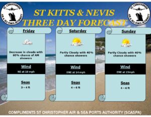
Weather forecast valid until 8:00am Thursday 29th August 20
Robert L. Bradshaw International Airport
St. Kitts Meteorological Services
St. Christopher Air & Sea Port Authority
P.O. Box 963
Basseterre
St. Kitts
Tel: 869 465 2749 Tele- fax: 869 465 9122
Weather Bulletin
Issued at: 7 am Wednesday 28th August, 2019
Present Weather: Cloudy with thunderstorm
Winds: A gentle breeze at 10 mph from the east
Temperature: 27°C/81°F Humidity: 88%
Sea Level Pressure: 1012.9mb or 29.91″
Sunrise: Tom 5:57 am Sunset: Today 6:28 pm
Weather Forecast Valid until 8am Tomorrow
Winds: Southeast with average speeds between 9 to 18mph with higher
gusts in some showers.
Seas: 1.5 to 2.1 meters or 5 to 7 feet; Small craft operators should
exercise caution in the waters west of the islands.
Weather Forecast for St. Kitts & Nevis: The proximity of Tropical
Storm Dorian to the islands along with a relatively warm southeasterly
windflow will enhance convective activity associated with feederband over
the Leewards today with a reduction in clouds and shower activity expected tonight. Rainfall accumulations could total between 13 to 32mm or 0.5 to 1.25 inches.
Weather today: Cloudy with occasional showers, some of which will be
moderate to heavy and thundery mainly during the afternoon.
Weather tonight: Decreasing clouds with lingering evening showers
with the chance of showers gradually decreasing overnight.
Eastern Caribbean Forecast: Tropical Storm conditions associated
with Dorian will be impacting Puerto Rico and the USVI and BVI tonight and
into tomorrow; as a result, tropical cyclone watches and warnings are in
effect for these islands. Weather conditions will gradually deteriorate around these islands later this afternoon leading to cloudy skies accompanied by moderate to heavy showers and windy conditions thereby increasing the risk of impacts that will threaten life and property. Lingering instability coupled by a warm southeasterly windflow will also ignite convective activity associated with feeder-bands over the Leewards. Meanwhile, an induced ridge coupled by a reduction in low-level moisture will lead to partly cloudy conditions with the possibility of brief showers over the Windwards and islands further south.