Published 28 July 2020
Buckie Got It, St. Kitts and Nevis News Source
St. Kitts Met Office.
Click on the PDF
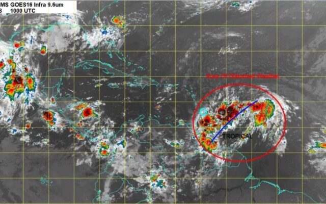
TROPICAL DISTURBANCE AL92 ALERT STATEMENT 855am 28th July, 2020
Robert L. Bradshaw International Airport
St. Kitts Meteorological Services
St. Christopher Air & Sea Port Authorities
P.O. Box 963
Basseterre
St. Kitts
Tel: 869 465 2749 Tele- fax: 869 465 9122
Urgent – Marine Weather Message
Small Craft Advisory
Antigua and Barbuda Meteorological Services
5:15 AM Tuesday 28 July 2020
A small craft advisory goes into effect today for the waters of Antigua and Barbuda, the rest of the Leeward Islands and the British Virgin Islands. This will likely be converted to a warning
Tuesday night or Wednesday.
Locations (to be) affected: Open waters.
Timing: Today until Friday.
Synopsis: Fresh to strong winds associated with the development of Tropical Disturbance AL92 are expected to cause the threat levels, at sea, to rise to high, with the potential of extensive impacts to the life and property of mariners. It is still very uncertain as to the eventual path, intensity and size of what may develop out of the Disturbance; depending on the various parameters, seas could be higher or lower.
Winds: Variable at 28 to 46 km/h (15 to 25 knots; 17 to 29 mph), with strong gusts to storm-force of around 70 km/h (38 knots; 44 mph).
Seas (significant wave heights): 2.5 to 4 metres (8 to 14 feet), occasionally or locally reaching over 5 metres (17 feet). Dominant wind wave period is 6 to 9 seconds.
Impacts (possible/likely/expected): Loss of life at sea; injuries to mariners; financial losses; disruption of fisheries and scarcity of fish products and disruption to marine transportation.
Precautionary/preparedness actions: A small craft advisory means that wind speeds of 21 to 33 knots and or wind waves and or wind swells of 7 feet or greater are expected to produce hazardous wave conditions to small crafts. Inexperienced mariners, especially those operating smaller vessels should avoid navigating in these conditions.
Please continue to monitor these hazardous, life-threatening marine conditions. Stay tuned to updates coming out of the Met Office via antiguamet.com
Forecaster: Dale Destin
Robert L. Bradshaw International Airport
St. Kitts Meteorological Services
St. Christopher Air & Sea Port Authorities
P.O. Box 963
Basseterre
St. Kitts
Tel: 869 465 2749 Tele- fax: 869 465 9122
TROPICAL CYCLONE ALERT STATEMENT
WHCA31 TAPA
TROPICAL CYCLONE ALERT STATEMENT
ANTIGUA AND BARBUDA METEOROLOGICAL SERVICES
855 AM ECT TUE, JUL 28, 2020
THIS IS FOR THE LEEWARD ISLANDS AND BRITISH VIRGIN ISLANDS
…
THIS IS FOR THE LEEWARD ISLANDS AND BRITISH VIRGIN ISLANDS
…A TROPICAL CYCLONE ALERT REMAINS IN EFFECT…
A TROPICAL CYCLONE ALERT REMAINS IN EFFECT FOR THE LEEWARD
ISLANDS AND THE BRITISH VIRGIN ISLANDS. A TROPICAL CYCLONE
ALERT MEANS, IN THIS CASE, A TROPICAL STORM IS EXPECTED TO
FORM IN OUR MONITORED AREA BUT A WATCH OR WARNING IS NOT
CURRENTLY REQUIRED.
IT IS DIFFICULT TO DETERMINE THE IMPACTS, AT THIS TIME.
NOTWITHSTANDING, AL92 IS FORECAST TO BE IN THE VICINITY IN THE
NEXT TWO DAYS AS, AT LEAST, A TROPICAL CYCLONE. LOCALLY
HEAVY RAINS AND GUSTY WINDS ARE LIKELY ACROSS PORTIONS OF
THE LEEWARD ISLANDS ON WEDNESDAY AND WILL SPREAD
WESTWARD TO THE VIRGIN ISLANDS WEDNESDAY NIGHT AND
THURSDAY.
THEREFORE, IT POSES A MODERATE THREAT WITH THE POTENTIAL TO
CAUSE SIGNIFICANT IMPACTS FROM STORM-FORCE WINDS,
ELEVATED STORM SURGE, EXTREME SEAS, MODERATE FLOODING
AND POSSIBLY A FEW TORNADOES, RESULTING IN LIFETHREATENING CONDITIONS, DISRUPTIONS TO DAILY LIFE AND SOME
DAMAGE TO INFRASTRUCTURE. TO BE SAFE, BE PREPARED TO
IMPLEMENT YOUR HURRICANE DISASTER PLAN.
AT 8 AM LST OR 1200 UTC, THE CENTRE OF TROPICAL DISTURBANCE
AL92 WAS LOCATED NEAR LATITUDE 14.0 NORTH, LONGITUDE 50.0
WEST OR ABOUT 816 MILES EAST-SOUTHEAST OF THE LEEWARD
ISLANDS OR ABOUT 1015 MILES EAST-SOUTHEAST OF THE BRITISH
VIRGIN ISLANDS; APPROXIMATELY 873 MILES SOUTH EAST OF
ST.KITTS AND NEVIS.
THE DISTURBANCE IS MOVING TOWARD THE WEST TO WESTNORTHWEST AT AROUND 15 TO 20 MPH. THIS MOTION IS EXPECTED TO
CONTINUE FOR THE NEXT COUPLE OF DAYS.
ALTHOUGH RECENT SATELLITE IMAGERY SUGGESTS THAT THE
SYSTEM DOES NOT YET HAVE A WELL-DEFINED CENTER, DATA FROM
NOAA BUOY INDICATE THAT THE SYSTEM IS PRODUCING WINDS NEAR
TROPICAL-STORM-FORCE STRENGTH. THE SYSTEM IS NOT YET A
TROPICAL CYCLONE AND MAXIMUM SUSTAINED WINDS ARE LESS
THAN 30 MPH HOWEVER THERE IS AN 80 PERCENT OR HIGH CHANCE
OF IT BECOMING ONE.
ON ITS PROJECTED FORECAST TRACK, AL92 COULD BE NEAR OR OVER
THE ISLANDS WEDNESDAY INTO THURSDAY, POTENTIALLY AS A
DEPRESSION OR TROPICAL STORM. HOWEVER, IT IS STILL A BIT TOO
EARLY TO SAY WITH HIGH CERTAINTY THE EVENTUAL PATH OF THE
SYSTEM, THE WIND INTENSITY ON ARRIVAL AND POSSIBLE RAINFALL
TOTALS.
RESIDENTS ARE URGED TO MONITOR TROPICAL DISTURBANCE AL92
AND BE PREPARED TO IMPLEMENT THEIR HURRICANE PLANS IN THE
EVENT THAT THE THREAT LEVEL FROM THIS SYSTEM SHOULD
INCREASE.
THE NEXT ADVISORY WILL BE AT 2 PM THIS AFTERNOON.
CLICK HERE FOR MORE INFORMATION
FORECASTER
LETITIA HUMPHREYS