Published 17 August 2020
Buckie Got It, St. Kitts and Nevis News Source
Hurricane center tracks 2 tropical waves heading for Caribbean with rising chance to develop
By RICHARD TRIBOU and JOE MARIO PEDERSENORLANDO SENTINEL |AUG 17, 2020 AT 1:42 PM

The 2020 season is continuing its tropical conveyor belt with the National Hurricane Center eyeing two more waves both having medium to high chances of developing into the next tropical depression or tropical storm.
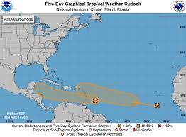
Both waves are located in the Atlantic but forecast to move into the Caribbean Sea in the next five days during which chances are good for tropical formation, the NHC said in its 2 p.m. Monday update.
The closer of the two is located about a few hundred miles east of the Windward Islands with disorganized rain and thunderstorms, and is trucking its way into the Caribbean at a fast forward speed of 20 mph, however that quick pace is believed to limit its development.
It is then expected to move over the Windward and southern Leeward Islands on Monday afternoon and slow down as it progresses into the Caribbean Sea.
PAID POST
What Is This?
“Upper-level winds could become more conducive for the development of a tropical depression during the latter part of this week,” forecasters said.
The NHC gives that system a 20 percent chance of formation in the next two days, but a 50 percent chance within the next five days.
Better chances are in play for a second tropical wave farther east in the Atlantic.
Located south-southeast of the Cabo Verde Islands, the wave has produced a large area of disorganized showers, forecast to move west to west-northwest at 15 to 20 mph in the next few days and interact with another system creating a large low pressure area.
The NHC gives that system a 30 percent chance of formation in the next two days, but a 70 percent chance within the next five days.
If either storm forms, it could become Tropical Depression 13 or if it spins up to tropical-storm-force strength with sustained winds of 39 mph, it would be named Tropical Storm Laura, the 12th named storm of the 2020 hurricane season, which runs through Nov. 30.
Last week, meteorologists were tracking Tropical Storm Josephine and Tropical Storm Kyle; the tenth and eleventh storms of the 2020 season. Both were unusual developments as the tenth storm of previous hurricane seasons is usually observed halfway into October.
The National Oceanic and Atmospheric Administration released its hurricane forecast for the 2020 season predicting an extremely active season with about 19 to 25 named storms.
The 2020 hurricane season already has seen seven tropical storms: Arthur, Bertha, Cristobal, Dolly, Edouard, Fay, Gonzalo, Josephine and Kyle plus Hurricane Hanna and Hurricane Isaias as well as a tropical depression that did not grow into named storm strength.