Published 27 September 2021
Basseterre
Buckie Got It, St. Kitts and Nevis News Source
Atlantic 5-Day Graphical Tropical Weather Outlook
ZCZC MIATWOAT ALL
TTAA00 KNHC DDHHMM CCA
Tropical Weather Outlook..
NWS National Hurricane Center Miami FL
800 AM EDT Mon Sep 27 2021
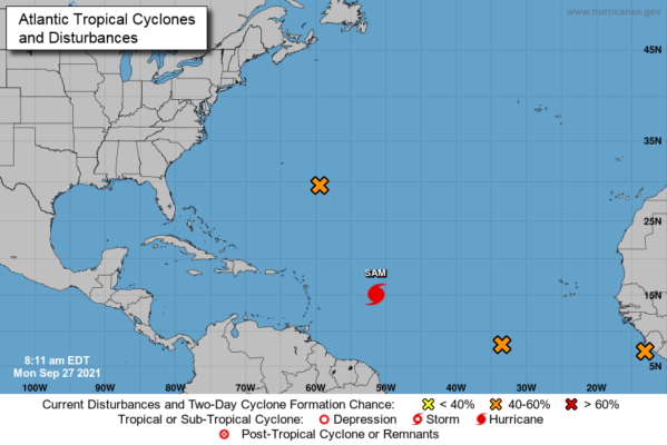
Corrected formation chances to medium in last two paragraphs For the North Atlantic…Caribbean Sea and the Gulf of Mexico: The National Hurricane Center is issuing advisories on Hurricane Sam, located several hundred miles east of the Lesser Antilles.
1. An elongated area of low pressure associated with the remnants of Peter is located a few hundred miles east-southeast of Bermuda. Showers and thunderstorms associated with this system have changed little in organization since yesterday. However, environmental conditions are marginally conducive for some further development, and Peter could briefly become a tropical depression again during the next day or two while it moves northeastward near 10 mph. By midweek, environmental conditions are expected to become unfavorable for further development.
* Formation chance through 48 hours…medium…50 percent.
* Formation chance through 5 days…medium…50 percent.
2. Disorganized showers and thunderstorms are associated with a broad area of low pressure located several hundred miles southwest of the Cabo Verde Islands. Environmental conditions are forecast to be conducive for further development of this disturbance, and a tropical depression is likely to form in a few days while it moves westward to west-northwestward at 5 to 10 mph over the central
tropical Atlantic.
* Formation chance through 48 hours…medium…40 percent.
* Formation chance through 5 days…high…80 percent.

3. A tropical wave is moving offshore the west coast of Africa and into the far eastern tropical Atlantic. Upper-level winds are forecast to be conducive for gradual development, and a tropical depression is likely to form in a few days while the system moves westward to west-northwestward at 10 to 15 mph over the far eastern tropical Atlantic.
* Formation chance through 48 hours…medium…40 percent.
* Formation chance through 5 days…high…80 percent.
Forecaster Hagen/Pasch