Published 19 September 2017
Buckie Got It, St. Kitts and Nevis News Source
WTNT35 KNHC 192357
TCPAT5
BULLETIN
Hurricane Maria Intermediate Advisory Number 15A
NWS National Hurricane Center Miami FL AL152017
800 PM AST Tue Sep 19 2017
…EYE OF CATEGORY 5 HURRICANE MARIA MOVING CLOSER TO ST CROIX IN
THE U.S. VIRGIN ISLANDS…
…PREPARATIONS AGAINST LIFE-THREATENING STORM SURGE AND RAINFALL
FLOODING AND DESTRUCTIVE WINDS SHOULD BE RUSHED TO COMPLETION…
SUMMARY OF 800 PM AST…0000 UTC…INFORMATION
———————————————-
LOCATION…17.0N 64.2W
ABOUT 60 MI…100 KM SE OF ST. CROIX
ABOUT 160 MI…255 KM SE OF SAN JUAN PUERTO RICO
MAXIMUM SUSTAINED WINDS…175 MPH…280 KM/H
PRESENT MOVEMENT…WNW OR 300 DEGREES AT 10 MPH…17 KM/H
MINIMUM CENTRAL PRESSURE…909 MB…26.84 INCHES
WATCHES AND WARNINGS
——————–
CHANGES WITH THIS ADVISORY:
The Meteorological Service of Antigua has discontinued the Hurricane Warning for St. Kitts, Nevis, and Montserrat. The Tropical Storm Warning and Hurricane Watch for Anguilla has also been discontinued.
SUMMARY OF WATCHES AND WARNINGS IN EFFECT:
A Hurricane Warning is in effect for…
* U.S. Virgin Islands
* British Virgin Islands
* Puerto Rico, Culebra, and Vieques
* Dominican Republic from Cabo Engano to Puerto Plata
A Tropical Storm Warning is in effect for…
* Saba and St. Eustatius
* St. Maarten
* Guadeloupe
* Dominican Republic west of Puerto Plata to the northern border of
the Dominican Republic and Haiti
* Dominican Republic west of Cabo Engano to Punta Palenque
A Hurricane Watch is in effect for…
* Saba and St. Eustatius
* St. Maarten
* St. Martin and St. Barthelemy
* Isla Saona to Cabo Engano
* Turks and Caicos Islands and the Southeastern Bahamas
A Hurricane Warning means that hurricane conditions are expected somewhere within the warning area. Preparations to protect life and
property should be rushed to completion.
A Tropical Storm Warning means that tropical storm conditions are expected somewhere within the warning area.
A Hurricane Watch means that hurricane conditions are possible within the watch area. A watch is typically issued 48 hours before
the anticipated first occurrence of tropical-storm-force winds, conditions that make outside preparations difficult or dangerous.
Interests elsewhere in Hispaniola and the Bahamas should monitor the progress of Maria.
For storm information specific to your area in the United States, including possible inland watches and warnings, please monitor products issued by your local National Weather Service forecast office. For storm information specific to your area outside
the United States, please monitor products issued by your national meteorological service.
DISCUSSION AND 48-HOUR OUTLOOK
——————————
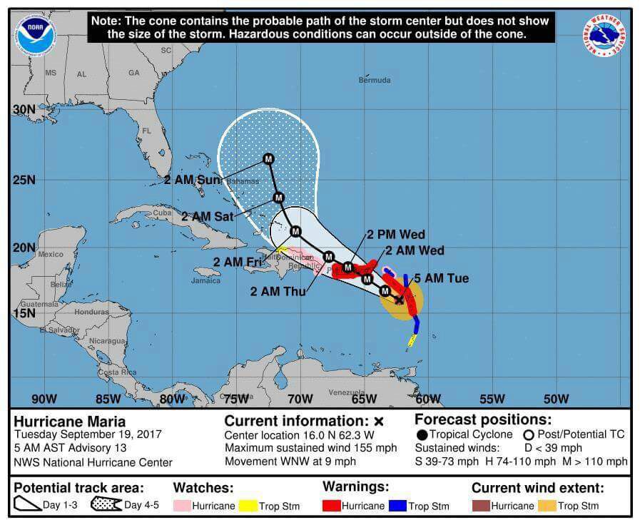
At 800 PM AST (0000 UTC), the eye of Hurricane Maria was located near latitude 17.0 North, longitude 64.2 West. Maria is moving
toward the west-northwest near 10 mph (17 km/h), and this general motion is expected to continue through Wednesday night. On the forecast track, the eye of Maria will move near or over St. Croix in the U.S. Virgin Islands tonight, cross Puerto Rico on Wednesday, and then pass just north of the coast of the Dominican Republic
Wednesday night and Thursday.
Reports from an Air Force Reserve Hurricane Hunter aircraft indicate that maximum sustained winds are near 175 mph (280 km/h) with higher gusts. Maria is a potentially catastrophic category 5 hurricane on the Saffir-Simpson Hurricane Wind Scale. Some fluctuations in intensity are likely during the next day or so, but Maria is forecast to remain an extremely dangerous category 4 or 5
hurricane as it moves near or over the Virgin Islands and Puerto Rico. Slow weakening is expected after the hurricane emerges over
the Atlantic north of Puerto Rico and the Dominican Republic.
Hurricane-force winds extend outward up to 35 miles (55 km) from the center and tropical-storm-force winds extend outward up to 140 miles (220 km).
The latest minimum central pressure reported by the Hurricane Hunter aircraft is 909 mb (26.84 inches).
HAZARDS AFFECTING LAND
———————-
WIND: Hurricane and tropical storm conditions will continue in portions of the warning area in the Leeward Islands this evening, and spread into the Virgin Islands and Puerto Rico tonight and Wednesday. Tropical storm conditions are spreading over the Virgin Islands at this time. Tropical storm conditions should begin spreading over Puerto Rico within the next few hours. Hurricane conditions are expected within the hurricane warning area in the Dominican Republic late Wednesday, with tropical storm conditions expected by early Wednesday. Tropical storm conditions are expected in the tropical storm warning areas in the Dominican Republic on Wednesday. Hurricane and tropical storm conditions are possible on Thursday in the Turks and Caicos Islands and the southeastern Bahamas.
Wind speeds atop and on the windward sides of hills and mountains and on high-rise buildings could be much stronger than the near- surface winds indicated in this advisory.
STORM SURGE: A dangerous storm surge accompanied by large and destructive waves will raise water levels by as much as 7 to 11
feet above normal tide levels in the hurricane warning area near where the center of Maria moves across the Leeward Islands and the British Virgin Islands.
A dangerous storm surge accompanied by large and destructive waves will raise water levels by as much as 4 to 6 feet above normal tide levels in the hurricane warning area in the Dominican Republic, and 1 to 3 ft elsewhere along the northern coasts of the Dominican Republic and Haiti.
The combination of a dangerous storm surge and the tide will cause normally dry areas near the coast to be flooded by rising waters moving inland from the shoreline. The water is expected to reach
the following heights above ground if the peak surge occurs at the time of high tide…
Puerto Rico and the U.S. Virgin Islands…6 to 9 ft
The deepest water will occur along the immediate coast near and to the north and east of the landfall location, where the surge will be accompanied by large and destructive waves. Surge-related
flooding depends on the relative timing of the surge and the tidal cycle, and can vary greatly over short distances. For information specific to your area, please see products issued by your local
National Weather Service forecast office.
RAINFALL: Maria is expected to produce the following rain accumulations through Thursday:
Central and southern Leeward Islands…10 to 15 inches, isolated 20 inches.
U.S. and British Virgin Islands…10 to 15 inches, isolated 20 inches. Puerto Rico…12 to 18 inches, isolated 25 inches. Northern Leeward Islands from Barbuda to Anguilla…4 to 8 inches, isolated 10 inches. Windward Islands and Barbados…2 to 4 inches, isolated 6 inches. Eastern Dominican Republic…4 to 8 inches, isolated 12 inches.
Rainfall on all of these islands will cause life-threatening flash floods and mudslides.
TORNADOES: Several tornadoes are possible over Puerto Rico and the U. S. Virgin Islands tonight and Wednesday.
SURF: Swells generated by Maria are affecting the Leeward Islands, Puerto Rico, and the Virgin Islands. These swells are likely tocause life-threatening surf and rip current conditions. Please consult products from your local weather office.
NEXT ADVISORY
————-
Next complete advisory at 1100 PM AST.