Published 24 September 2018
Buckie Got It, St. Kitts and Nevis News Source
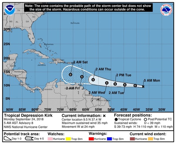
Tropical Depression Kirk continued on a fast track toward the Caribbean — but there’s a chance it may not make it there, according to forecasters.
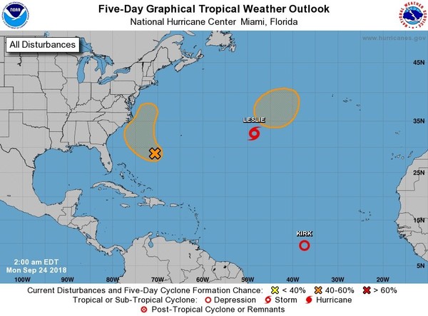
The National Hurricane Center on Monday is also tracking Subtropical Storm Leslie and two other areas in the Atlantic.
Kirk is the only storm that could affect land, and if it did it wouldn’t be until later this week.
As of 4 a.m. CDT Monday, Tropical Depression Kirk was located about 1,615 miles east of the Windward Islands and was moving west at 24 mph.
Kirk had winds of 35 mph, according to the hurricane center.
Forecasters there said Kirk could get a bit stronger and become a tropical storm again — or it could fall apart altogether.
Kirk’s quick pace is not allowing it to get more organized, but that could change by Wednesday when the storm is expected to slow down a bit.
Kirk is forecast to reach the Lesser Antilles by early Friday, but increasing wind shear could cause it to weaken more and even dissipate by the time it enters the Caribbean.
Subtropical Storm Leslie also has a murky future as of Monday morning.
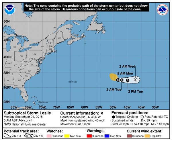
As of 4 a.m. CDT Leslie was located about 1,270 miles west of the Azores and was moving south at 6 mph.
Leslie had winds of 40 mph, making it a minimal subtropical storm.
Leslie isn’t expected to move much today and could merge with a frontal system in two or three days.
The hurricane center said Leslie could become an extratropical storm at that time — and could later merge with another low that the hurricane center is also watching for development to Leslie’s north.
The hurricane center said that merged system has a 50 percent chance of again acquiring some subtropical or tropical characteristics over the next five days.
The final area being watched by the hurricane center contains the remnants of Hurricane Florence.
On Monday morning it was a broad area of low pressure located halfway between the Bahamas and Bermuda.
It has a 40 percent chance of development over five days and is expected to track toward the southeast U.S. coast.
However, upper-level winds are forecast to become unfavorable near the coast and development by then will be unlikely.


