Published 17 August 2017
Buckie Got It, St. Kitts and Nevis News Source
Potential Tropical Storm Harvey is Heading to the Windward Islands
BRIDGETOWN, Barbados, Thursday August 17, 2017 – A tropical depression that forecasters say is likely to become Tropical Storm Harvey later today is headed for the Windward Islands.
A tropical storm warning is now in effect for Barbados, St Lucia, Martinique and St Vincent and the Grenadines while a tropical storm watch has been issued for Dominica.
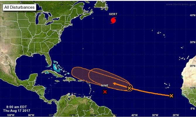
At 11 a.m., when the National Hurricane Centre (NHC) in Miami issued its first bulletin on potential tropical cyclone number nine, the depression was 365 miles east of Barbados and 465 miles east of St Lucia and carrying maximum sustained winds near 35 miles per hour.
The system is moving toward the west near 17 miles per hour and that motion is expected to continue for the next couple of days. On the forecast track, the disturbance should move through the Windward Islands and into the eastern Caribbean Sea tomorrow.
“The disturbance is expected to become a tropical cyclone later today or tonight, and it could become a tropical storm before reaching the Windward Islands. If the current trends continue, the system will likely become a tropical cyclone later today or tonight. An Air Force Reserve Hurricane Hunter aircraft is scheduled to investigate the disturbance this afternoon,” the NHC said.
Tropical storm conditions are expected to first reach the Lesser Antilles within the warning area by early tomorrow, while tropical storm conditions are possible in the watch area tomorrow.
The system is expected to produce rainfall totals of 2 to 4 inches across portions of the Windward Islands from Martinique southward to Grenada.
“These rains could cause life-threatening flash floods and mudslides,” the NHC warned.
Meantime, elsewhere in the Atlantic another potential storm is brewing. Shower activity associated with a second area of low pressure located about midway between the coast of Africa and the Lesser
Antilles has also become a little better organized.
“Continued gradual development of this system is possible during the next couple of days while it moves west-northwestward at 15 to 20 mph, but upper-level winds are expected to become less conducive for tropical cyclone formation when the disturbance moves north of the Leeward Islands this weekend,” the NHC said, adding that it has a 50 to 60 per cent chance of developing over the next two to five days.
There is also a tropical wave located over the far eastern Atlantic Ocean near the Cabo Verde Islands which is producing disorganized showers and thunderstorms. The NHC said gradual development of this system is possible during the next several days while it moves westward to west-northwestward at about 15 mph. It has a low to medium chance of development.