Published 1 July 2017
Buckie Got It, St. Kitts and Nevis News.
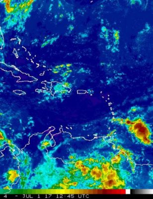
Tropical Wave approaching the Windward Islands this evening and the Leeward Islands tomorrow Sunday.
Good afternoon everyone,
It looks like Disturbance 15 day forecast by the US National Hurricane Centre has been cranked up a bit.
NWS National Hurricane Center Miami FL
200 PM EDT Sat Jul 1 2017
“A tropical wave located about 450 miles southwest of the Cabo Verde Islands continues to produce a broad area of disorganized showers and thunderstorms. Environmental conditions are expected to be conducive for gradual development during the next several days while the disturbance moves westward at about 10 mph.”
* Formation chance through 48 hours…low…10 percent.
* Formation chance through 5 days…medium…40 percent.
Graphic attached.
Early days but needs to be monitored by those in the Leeward and Windward Islands.
Regards,
Frank Goodwill
Pond Hill, Nevis, KN Weather Station:
https://www.wunderground.com/personal-weather-station/dashboard?ID=ISAINTGE418
Weather Webcams:
https://map.bloomsky.com/weather-stations/gqBxp6apnJSnnZu2
https://map.bloomsky.com/weather-stations/eaB1rJytnpS4qZqn
Attachment: two_atl_5d0.jpg
Description: two_atl_5d0.jpg
– Monitoring A Disturbance
By Frank Goodwill <nevis.storm at hotmail.com>
Date: Sat, 1 Jul 2017 17:16:58 +0000
Good afternoon everyone,
It looks as if the Tropical Wave that was forecast to effect Nevis on Sunday is not going to now as it has tracked further south (Trinidad, Tobago and the south Windward Islands).
The Saharan Air Layer is back with us after a short break producing some hazy conditions due to the associated dust.
Out in the Atlantic a couple more Tropical Waves are on there way. The first one is being monitored
by the US National Hurricane Center and has been designated as ‘Disturbance 1’. At the moment it looks like a slow developer.
NHC Forecast Text:
“A tropical wave located about 400 miles southwest of the Cabo Verde Islands is producing an area of disorganized showers and
thunderstorms. Environmental conditions are expected to be conducive for gradual development during the next several days
while the disturbance moves westward at 10 to 15 mph.”
* Formation chance through 48 hours…low…near 0 percent.
* Formation chance through 5 days…low…20 percent.
The graphic is attached.
As always it’s early days regarding development but as they say “it only takes one”.
As for the forecast for Nevis over the next few days.
The air mass across the area is relatively dry and stable with hazy conditions. This will keep cloudiness and showers to a minimum. By Tuesday there maybe a build up of cloud over the island.
Temperatures: High 31C (93F) Low 25C (77F)
Slightly lower temperatures on Tuesday if there is a build up of cloud.
Winds: ENE-E at 10-15 kt, 19-28 km/h
Seas: Moderate with waves 1.5-1.8m/5-6ft.
Small craft operators should exercise caution against marginally safe seas.
Attached photos:
NHC 5 day view of Disturbance 1
Today’s sky views of Nevis.
Regards,
Frank Goodwill
Pond Hill, Nevis, KN Weather Station:
https://www.wunderground.com/personal-weather-station/dashboard?ID=ISAINTGE418
Weather Webcams:
https://map.bloomsky.com/weather-stations/gqBxp6apnJSnnZu2
https://map.bloomsky.com/weather-stations/eaB1rJytnpS4qZqn
Attachment: two_atl_5d0.jpg
Description: two_atl_5d0.jpg
Attachment: sky_image.jpg
Description: sky_image.jpg
Attachment: sky_image1.jpg
Description: sky_image1.jpg