Published 17 September 2017
Buckie Got It, St. Kitts and Nevis News Source
A Hurricane Warning is in effect for hurricane Maria in St. Kitts.
A Hurricane Warning is in effect for hurricane Maria in St. Kitts. Current storm track is to the south of St. Kitts, and expected to be a hurricane Category 3 hurricane by late Tuesday. Tropical storm force winds expected in St. Kitts by mid-Tuesday morning with hurricane force winds in the afternoon. Winds estimated at 75 MPH with gusts to 100MPH, and rainfall is expected in the 4-8″ range. Please also be aware that there is still debris from hurricane Irma, please exercise caution as we experience high winds.
Hurricane Maria Intermediate Advisory Number 6A
NWS National Hurricane Center Miami FL AL152017
800 PM AST Sun Sep 17 2017
…MARIA CONTINUING TO STRENGTHEN AS IT APPROACHES THE LESSER
ANTILLES…
SUMMARY OF 800 PM AST…0000 UTC…INFORMATION
———————————————-
LOCATION…14.0N 57.9W
ABOUT 125 MI…200 KM ENE OF BARBADOS
ABOUT 255 MI…410 KM ESE OF DOMINICA
MAXIMUM SUSTAINED WINDS…80 MPH…130 KM/H
PRESENT MOVEMENT…WNW OR 285 DEGREES AT 15 MPH…24 KM/H
MINIMUM CENTRAL PRESSURE…982 MB…29.00 INCHES
WATCHES AND WARNINGS
——————–
CHANGES WITH THIS ADVISORY:
The Government of France has issued a Hurricane Warning for
Martinique.
SUMMARY OF WATCHES AND WARNINGS IN EFFECT:
A Hurricane Warning is in effect for…
* Guadeloupe
* Dominica
* St. Kitts, Nevis, and Montserrat
* Martinique
A Tropical Storm Warning is in effect for…
* Antigua and Barbuda
* Saba and St. Eustatius
* St. Lucia
A Hurricane Watch is in effect for…
* U.S. Virgin Islands
* British Virgin Islands
* Saba and St. Eustatius
* St. Maarten
* St. Martin and St. Barthelemy
* Anguilla
A Tropical Storm Watch is in effect for…
* Barbados
* St. Vincent and the Grenadines
A Hurricane Warning means that hurricane conditions are expected somewhere within the warning area. A warning is typically issued 36 hours before the anticipated first occurrence of tropical-storm- force winds, conditions that make outside preparations difficult or dangerous. Preparations to protect life and property should be rushed to completion.
A Tropical Storm Warning means that tropical storm conditions are expected somewhere within the warning area within 36 hours.
A Hurricane Watch means that hurricane conditions are possible within the watch area. A watch is typically issued 48 hours before the anticipated first occurrence of tropical-storm-force
winds, conditions that make outside preparations difficult or dangerous.
A Tropical Storm Watch means that tropical storm conditions are possible within the watch area, generally within 48 hours.
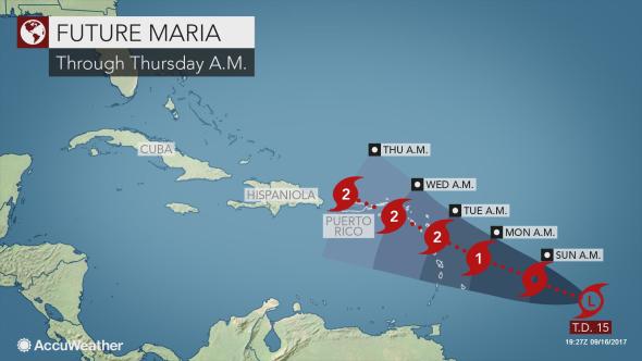
Interests elsewhere in the Lesser Antilles and Puerto Rico should monitor the progress of this system. Additional Tropical Storm or Hurricane Watches and Warnings will likely be issued tonight or on Monday.
For storm information specific to your area, please monitor products issued by your national meteorological service.
DISCUSSION AND 48-HOUR OUTLOOK
——————————
At 800 PM AST (0000 UTC), the center of Hurricane Maria was located by the French radar on Martinique near latitude 14.0 North,
longitude 57.9 West. Maria is moving toward the west-northwest near 15 mph (24 km/h), and this motion with a decrease in forward speed
is expected through Tuesday. On the forecast track, the center of Maria will move across the Leeward Islands Monday night and then over the extreme northeastern Caribbean Sea on Tuesday.
Maximum sustained winds have increased to near 80 mph (130 km/h) with higher gusts. Additional strengthening is forecast during the
next 48 hours, and Maria could be near major hurricane intensity when it moves across the Leeward Islands Monday night.
Hurricane-force winds extend outward up to 15 miles (30 km) from the center, and tropical-storm-force winds extend outward up to 105 miles (165 km).
The estimated minimum central pressure is 982 mb (29.00 inches).
HAZARDS AFFECTING LAND
———————-
WIND: Hurricane conditions are first expected within portions of the Leeward Islands by Monday night, with tropical storm conditions beginning on Monday. Hurricane conditions are possible within the hurricane watch area by Tuesday, with tropical storm conditions possible Monday night. Tropical storm conditions are possible in the tropical storm watch area Monday or Monday night.
STORM SURGE: A dangerous storm surge accompanied by large and destructive waves will raise water levels by as much as 4 to 6 feet
above normal tide levels near where the center of Maria moves across the Leeward Islands.
RAINFALL: Maria is expected to produce total rain accumulations of 6 to 12 inches with isolated maximum amounts of 20 inches across the Leeward Islands, including Puerto Rico and the U.S. and British Virgin Islands, through Wednesday night. Maria is also expected to produce total rain accumulations of 2 to 4 inches for the northern and central Windward Islands. In all the above areas, these rainfall amounts could cause life-threatening flash floods and mudslides.
SURF: Swells generated by Maria are affecting the Lesser Antilles. These swells are likely to cause life-threatening surf and rip current conditions. Please consult products from your local
weather office.
NEXT ADVISORY
————-
Next complete advisory at 1100 PM AST.
$$
Forecaster Beven